Over the last few years, we have been diligently working towards our goal of having a new foundation for our demographic data that takes advantage of the flood of data now available while preserving consistency with the census and its geographic areas.
On the census side our focus is primarily at the census block level as the base geographic area, even if most of our clients utilize data at the block group or as trade area aggregates. The block as a base for our data development provides two main benefits – they are stable and aggregate easily into familiar areas like ZIP codes and isochrone polygons and they are extremely detailed with over nine million objects.
Block data represents the aggregated data of what are the core objects of interest to us – people and households, buildings, and businesses. As regular readers know, we are pursuing an aggressive strategy of creating this foundation level data – essentially for individual buildings, parcels, and businesses. The goal is to integrate and harmonize these sources to other data (census, postal delivery counts) first at the census block level, then for the geographic areas that users actually want.
While we are still working on things – especially the textual analysis of government documents and local newspapers and the automation of satellite imagery analytics – many of the core components are now in place and have a year of testing behind us. The time has come to begin to release these to users.
Beginning with our 2026A release in May, our Parcels and Permits database will provide useful summaries of the underlying chaos of millions of records.
On the parcel side, we have two main components – inventory and change – with a series of data tables that will be available for any geographic area. These tables include:
- Total parcels
- Parcels by addressability (e.g. can you send mail to it)
- Parcel land use
- Parcel size (and size by land use)
- Building size
- Bathroom and bedroom counts
- Parcel amenities (such as a swimming pool)
- Property taxes
- Length of ownership
- Ownership and tenure
Since our parcel data is compiled quarterly, we are also able to begin to track changes in land use, parcel geometry, and ownership in order to pinpoint areas where significant development is on the horizon.
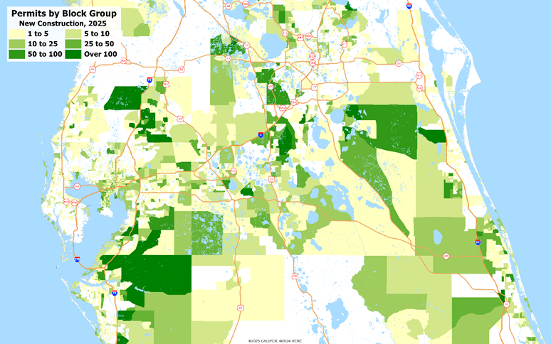
Tracking building permits, even though they do not have complete national coverage, remains one of the best ways to understand the changes going on in any census block. We have summarized permit activities into several groups –
- All permits
- Residential
- New construction
- ADU
- Other permits (renovations and many maintenance activities)
- Commercial
- Residential
- Currently open permits
These are available both for annual summaries – covering 2017 to 2025 – and for quarterly summaries. For quarterly summaries, we will generally carry the last 8 quarters. Together, these provide excellent insights into both current and recent developments that affect the buildings and housing stock of an area.