One of the hallmark characteristics of both American and Canadian census geography is that the base layer must completely tesselate the national territory. Simply put, if you take all of the census blocks of the United States and map them, the entire country will be covered.
The FIPS (federal information processing series) code is easily decoded and includes embedded nuggets of information. For example, if the first digit of the block code is a 0, it is a water block.
| 0 | 6 | 0 | 3 | 7 | 2 | 4 | 5 | 9 | 0 | 1 | 3 | 0 | 0 | 1 | A |
| State | County | Census Tract | Tract Suffix | Block Group | Block | Block Suffix (optional) | |||||||||
A typical block map in the United States looks like this –
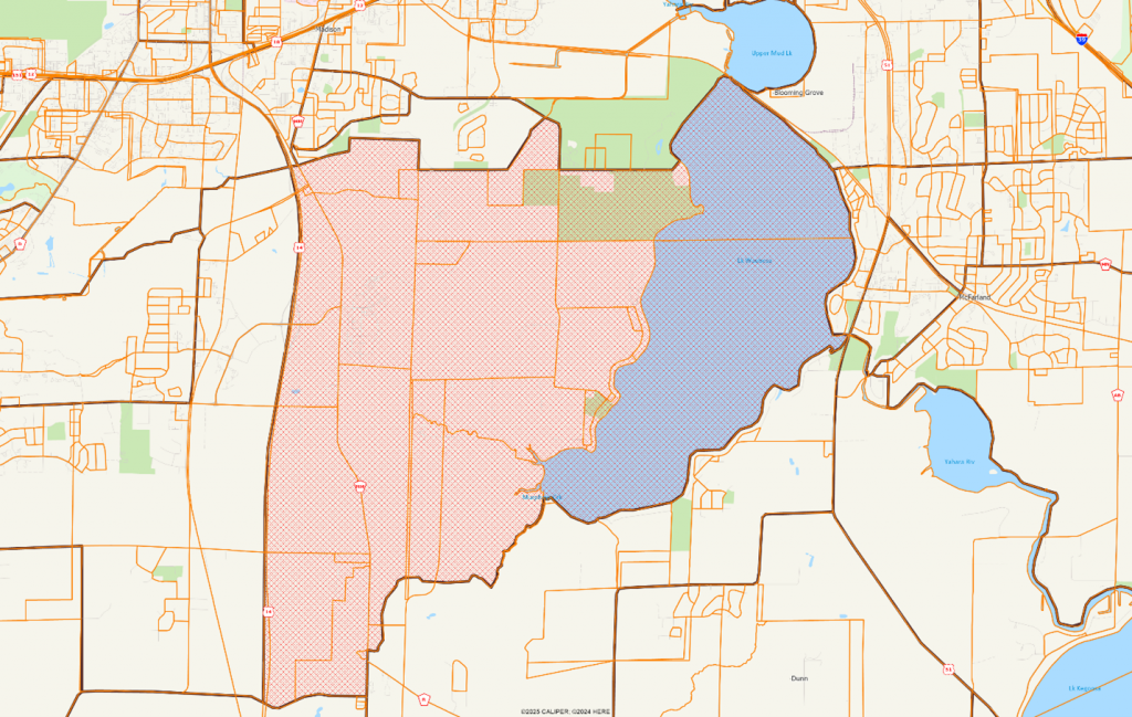
Note that the blocks cover the territory completely and generally follow street center lines, natural features such as rivers and lakes, and non-physical lines such as administrative boundaries and parcels. In the example shown, the block group includes the lake, which is split into two separate blocks, each with a block identifier that begins with 0. Along the western edge of the block group we can see a ‘sliver’ block – these can be created along roads which have a median or at freeway interchanges.
The system adopted in Canada is similar – the Dissemination Block (DB) is the smallest geographic area, and the code is hierarchical:
| 3 | 5 | 2 | 0 | 1 | 8 | 4 | 5 | 0 | 0 | 7 |
| Province or Territory | Census Division | Dissemination Area | Dissemination Block | |||||||
The result is that when you map either block groups or dissemination areas, you will get complete coverage of the country. Some areas might cover thousands of square miles, but the surface is fully tessellated.
In Mexico, however, things are somewhat different. A clear distinction is drawn between urban and rural areas, where urban areas are defined as clusters of population with 2,500 persons or more, or are the municipio (county) seat.
Urban areas, also known as localities, are divided into areas known as manzanas and clustered into AGEB units, which we will respectively call blocks and block groups.
An area of Puerto Vallarta is shown below, with the blocks highlighted within a single block group:
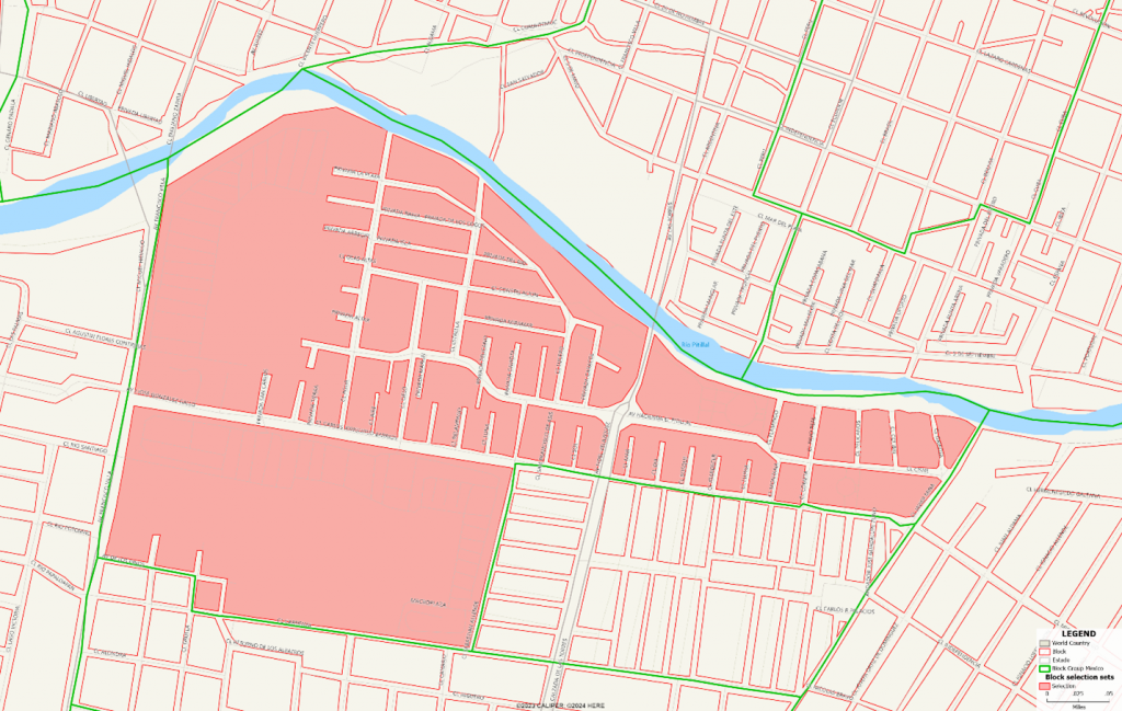
Note that the blocks do not extend to the street centerline and do not fully tesselate the block group space. This has implications for map display, as it can be disconcerting when drawing thematic shaded maps. For most mapping applications, we recommend using the BG (block group) layer.
However, in rural areas we have a different issue where the AGEB unit is not defined. In rural areas, localities are defined as a named place with one or more dwellings, with no occupancy requirement. There are nearly 300,000 such localities nationwide and range in scope from single isolated dwellings to Mexico City. Rural localities are often defined only as points or a collection of points with a boundary loosely drawn around them. They are inconsistently defined and do not cover the territory completely. In part, this reflects a different settlement pattern than was common in the US or Canada.
For our purposes, we converted rural areas into block groups, modifying or adding the shape of the area as needed. The results are still inconsistent, as shown below:
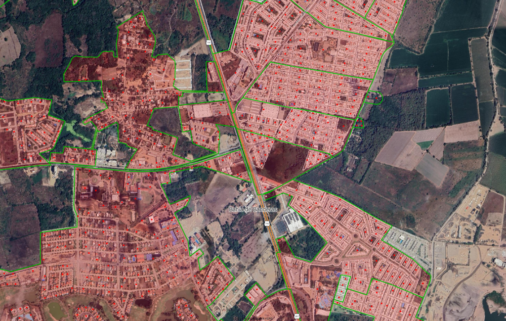
On the west side, we have rural localities defined as points only, and on the east side we have manzanas (blocks) defined as areas. In between, there are non-block group areas which clearly have buildings that are neither defined as localities or urban AGEBs. The treatment of developed areas can be quite inconsistent.
The coding is simple, and uses 13 characters for the detailed block group level:
| 0 | 1 | 0 | 0 | 1 | 0 | 0 | 0 | 1 | 0 | 0 | 6 | A | 0 | 0 | 7 |
| State | Municipio | Locality | Block Group (AGEB) | Block (Manzana) | |||||||||||
Since AGEB’s are not defined in rural areas, these block groups will have “0000” as the block group portion of the coding in order to allow a consistent format nationwide.
So what levels of geography are we able to offer and how can they be used?
| Layer | # Features | Type | Notes | Usage |
| Blocks | 5,874,071 | Area and Point | Inconsistently defined in urban areas | Detailed thematic mapping in urban areas.
Radius and polygon retrieval. |
| Block Groups | 248,503 | Area | Not defined in unpopulated rural areas | Thematic mapping |
| Localities | 296,814 | Area / Point | Inconsistent definitions | Not recommended |
| Municipios | 2,469 | Area | Roughly equivalent to a county | Regional and national scale thematic mapping |
| State | 32 | Area | Roughly equivalent to a Canadian province or US state | National scale thematic mapping |
| Hexagon Level 3 | 214 | Area | National scale thematic mapping, analytics | |
| Hexagon Level 4 | 1,166 | Area | National and regional scale thematic mapping, analytics | |
| Hexagon Level 5 | 7,286 | Area | Regional and metropolitan scale mapping and analytics | |
| Hexagon Level 6 | 48,565 | Area | Metropolitan scale mapping and analytics | |
| Hexagon Level 7 | 333,561 | Area | Local scale mapping and analytics |