
As we told you about a few months back, the geographic rosters for Connecticut are changing. The counties are being replaced by a new set of areas that are being called ‘Planning Regions’ and will be considered as part of the county level of geography. These changes are already starting to occur and have begun to impact users. Those who have downloaded the latest TIGER derived files will now find missing data for the entire state. Also, the Census ACS 1-year and 5-year data released later this year will use these new county codes. Of course, we have options for you.
First, let’s go through the changes. Gone are the familiar names of the eight counties in the state and replacing them are nine planning regions. A map showing the old (red) and new boundaries (green) is shown below:
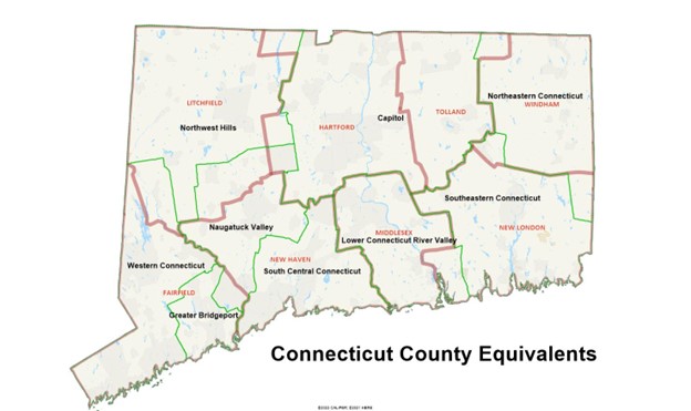
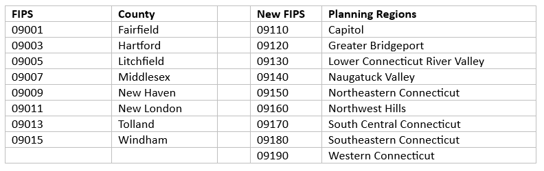
While they often follow the historic county lines, this is of course not possible when going from eight to nine regions. The old and new codes for Connecticut are:
Of course, the block, block group and tract codes are affected, as the first five digits of their ids have changed. There are a couple of block groups and census tracts that have been split, but for the census blocks are a one-to-one match.
Our question remains, why didn’t the state time things for the 2020 census? It would have made life much easier. What does that mean for you? Starting with 2023A, we will now offer four block group rosters so that you have the data that best fits your needs. The rosters are as follows:
BG 2020 Census Block Groups, as delivered
B1 2017 Block groups (2010 boundaries with 2017 adjustments)
B2 2014 Block Groups (2010 boundaries with 2014 adjustments)
BN 2022 Block groups (2020 boundaries with 2022 adjustments to Connecticut)
Of course, if you need TR (Census Tract) and CO (County, and county equivalents) for any of these vintages, we can deliver those too! Just another way that AGS ensures that data delivery is done right.

What does this accomplish? Are there any advantages to the citizens? What advantages are there for the state?