
One of the great benefits of web enabled applications is the ability to quickly add substantial functionality simply by using external specialized APIs that minimize development and maintenance time. The Snapshot API is an easy way to add demographic reports to your geospatial applications.
The Snapshot report generator is a flexible PDF reports for any combination of our nearly 36000 elements for the United States and 2000 for Canada. The key features are –
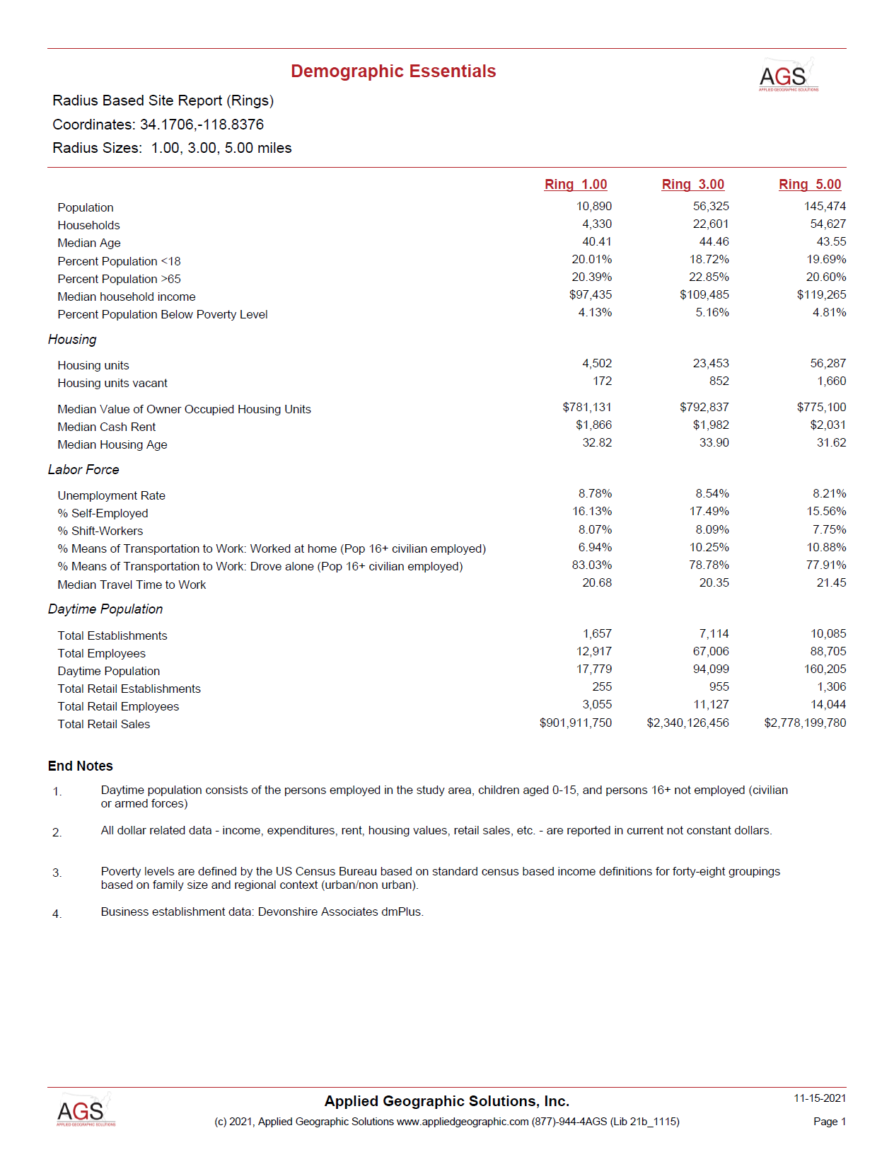
- Support for radius, drive time, custom polygon, and standard geographic areas (ZIP codes, counties, etc.)
- Flexible benchmarks including saved report objects (“sister” store comparisons), standard geographic areas, and our advanced percentile and z-score comparisons
- Simple styling using pre-defined or custom style sheets which incorporate color and shading, font selection and sizing, and highlighting
- Customization of logos and footer text, giving the reports your company look and feel
Most geospatial applications are map centric, and Snapshot reports are designed to permit the insertion of your map output directly into the report using our BYOM (“bring your own map”) capabilities. And these aren’t limited just to maps, you can import satellite imagery and even photographs of your site.
At the heart of the system is the Snapshot variable list, which consists of a mixture of individual variables, pre-defined tables such as “households by income” or “population by age”, automatic percentage computations, and an impressive array of over fifty functions that redefine the simple site report. These include –
- min() and max() for any variable to understand not just the median household income, but how it ranges within the trade area
- embedded regression equations which directly enable model estimates to be embedded in reports
- diversity() and inequality() functions
- variable reclassification and rescaling, with optional text labels
- logical testing and site comparison measures
- interpolation and forecasting functions
Snapshot is a highly optimized geospatial processing engine that can be called via the API or used directly on your Windows based servers. The API interface is simple and can be implemented within a matter of minutes, meaning that effort is spent where it belongs – on report content and design rather than database management and software development.
Interested in adding site reports to your applications? We would be delighted to show you just how easy and cost-effective the Snapshot solution can be.

Recent Comments